San Jacinto River Caching

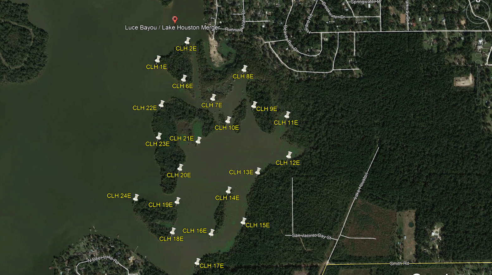
Central Lake Houston East (CLH XE)

Central Lake Houston.jpg

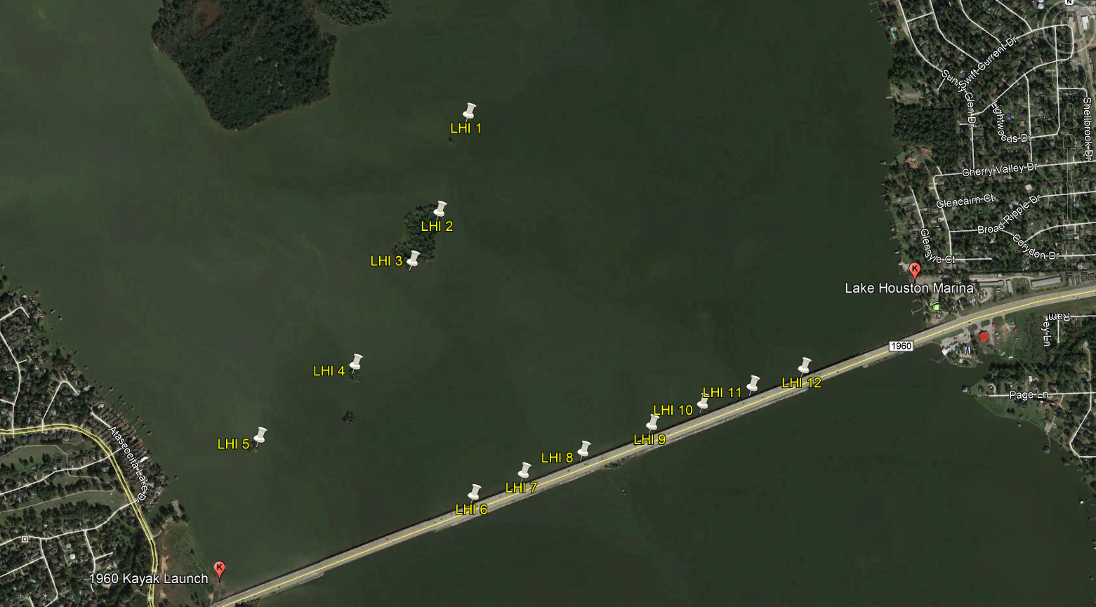
The “Central Lake Houston” caches are denoted by cache names CLH XE, CLH XC, CLH XW, & Lake Houston Islands (LHI X) depending on which section of the lake they lie in. The area is bounded to the north and east by the merger of Luce Bayou into Lake Houston, to the south by the FM1960 Bridge, and to the west by the West Lake Houston Bridge.  Depending on which group of caches you are after determines the best launch point.

Central Lake Houston East GPS Points

CLH XE caches require the longest paddle and can be reached by launching from BJ’s Marina to the north, Lake Houston Marina to the south, or Ponderosa Marina up Luce Bayou.

  • BJ's Marina
    • N 30° 3.529'
    • W 95° 7.910'
    • BJ’s Marina charges a $5 fee for launching.
    • A motorized boat, on a trailer, may be launched at BJ’s however due to the low angle of the ramp it is only recommended for use by flat bottom jons and similar type boats.  We recommend Ponderosa Marina or Lake Houston Marina for the launching of larger boats.


  • Lake Houston Marina
    • N 30° 1.120'
    • W 95° 7.150'
    • Lake Houston Marina charges a $10 fee for launching.


  • Ponderosa Marina
    • N 30° 3.384'
    • W 95° 5.955'
    • Ponderosa Marina charges a $7 fee for launching.


Central Lake Houston East

Central Lake Houston East

Central Lake Houston Central (CLH XC)

Central Lake Houston.jpg

Central Lake Houston Central GPS Points

  • Scenic Shore Park
    • N 30° 2.540'
    • W 95° 9.247'
    • CLH XC caches are easily reached launching from Scenic Shore Park.  This is a small park that provides entry to the Kingwood Greenbelt and is privately owned by the Kings Point Trails Association.  Typically there is no complaints from others using the area as long as people are respectful and there is not a lot of road traffic.  While legal to park along the street we do not recommend it as this typically leads to the local residents calling the police who will the question why you are in the park.  In the event you want to launch from Scenic Shore Park please reach out to Team 150% or G&N Geocachers to coordinate parking. 


  • 1960 Kayak Launch
    • N 30° 0.611'
    • W 95° 8.528'
    • Alternatively you could launch from the 1960 Kayak Launch.  This is private property as far as we are aware however we regularly see the public fishing from the bank here with no issues.  Park at your own risk.


CLH Central.jpg

Central Lake Houston West (CLH XW)

Central Lake Houston.jpg

Central Lake Houston West GPS Points

  • Kings Harbor Dock
    • N 30° 1.858'
    • W 95° 10.376'
    • CLH XW caches are easily reached by launching from the Kings Harbor Dock.  This is the commercial area on the lake that has multiple restaurants such as Sharky’s, Raffas, etc and would make a great place to host an event.  We do not recommend parking here without coordinating permission from one of the restaurants.  If not eating we see no issue however having someone dropping you out here to launch.  Alternatively you could launch from Scenic Shore Park as listed on the CLH Central Page which adds ~ 0.5 miles of paddling to the trip.
CLH West.jpg

Lake Houston Islands (LHI)

Central Lake Houston.jpg

Lake Houston Islands GPS Points

LHI caches are easily reached by launching from either Lake Houston Marina or from the 1960 Kayak Launch. 

  • Lake Houston Marina
    • N 30° 1.120
    • W 95° 7.150
    • Lake Houston Marina charges a $10 fee for launching.


  • 1960 Kayak Launch
    • N 30° 0.611'
    • W 95° 8.528'
    • This is private property as far as we are aware however we regularly see the public fishing from the bank here with no issues.  Park at your own risk.
Lake Houston Islands

Lake Houston Islands